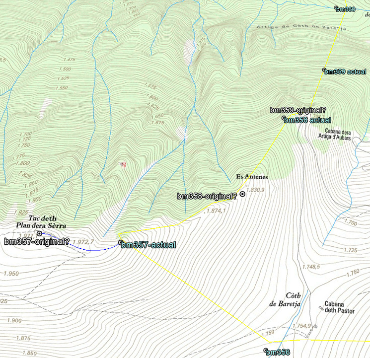
The original bordercross 359 has never been found on the steep rugged hillside between bm358 and 360. I wrote a large article on this matter, concluding that the borderline on that hillside is not correct. Therefore bm359 should be searched at another spot but still on that steep hillside.
But a new hypothesis sprung to my mind recently. In short: both bm357 and 358 were reconstructed on the wrong places in the 1950-ies and the original bm359 was thus engraved at the beginning of the steep hillside, not in the middle. Let’s show it on the map:
Let’s explain: after WWII all esfr-bordermarkers were surveyed and reconstructed when needed. Jean Sermet writes in his “Journal de la restauration de l’abornement de la Haute Garonne” (1957) that – in the Haute-Garonne – all borderpillars had disappeared in the well accessible parts of the borderline. In the replacing-process the original spots had to be established again, using the descriptions of the treaty of 1863 and in some rare cases the remains of the original masonry pillars.
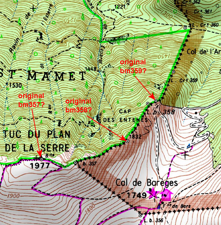
The treaty of 1863 says that bm357 was placed at the “piton ou Tuc du Plan de la Serre” and that’s a well recognizable and plausible summit. BUT: the actual bm357 (from the 1950-ies) is constructed at the ridge ± 250m E downhill. You can see that perfectly on this picture.
One could say bm357 is placed at a sub-summit but definitely not at THE summit. Why? I can’t find any explication but there’s an account of a discussion on this subject in the report on “Abornement des pâturages espagnols en Haute-Garonne” from Jean Sermet on page 7. His Spanish counterpart M. Alija believed that bm357 should have been at the summit.
If we assume that the original bm357 was at the summit, it changes inevitably the position of bm358 and 359 because the treaty states explicitly the distances in between. Using the distance-calculator within Google Earth and counting the 602m along the ridge, the original bm358 would have been placed at a sub-summit (‘Es Antenes’ on the Catalonian topographic map, the treaty says: “au camp de Enténès”). Subsequently – after 330m – the original bm359 must have been engraved in a rock at the end of the ridge. And that’s a bit further – I think – than the new bm358. And that’s where the (very) steep hillside starts towards bm360.
Am I right? Well, it all fits much better in the treaty-description and in the topography and I’m pretty sure this is the way it was. Jean Sermet writes that the location of bm358 was indisputable (at its current position) but he gives no argument for that. In any case, I don’t see remains of the original mansonry bm358 at my pictures which would have been the very proof indeed.
In july Jan-Willem and I will return to the Haute-Garonne and see if we can find any confirmation. And to finish: the hypothesis on the Catalonian topographic maps: