How France has lost 8 hectares … secretly

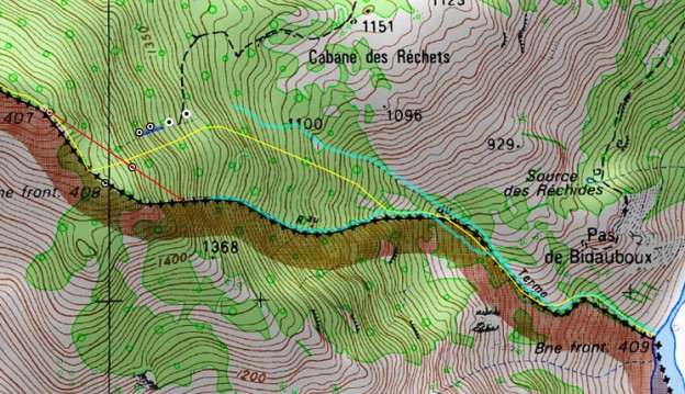
In the Pyrenees, close to Bagnères-de-Luchon at the Bidaubus-hillside, France has lost 8 hectares for no reason. In a way, it is kept secret, decided upon in closed meetings with no publicity or justification. Can it be reversed? The Bayonne Treaties 1856-1868 France has a vast length of borders with its neighboring countries. In the […]

New update GRPdesBF-website

I’m glad to announce a new update of my website.   What’s new (main changes): – added the 15 daytrips from july/december 2017. Start on this page – special 1: final (?) search with Charles Darrieu, Michel Molia and Henny Claassen for the 408-submarkers 408 III and IV – special 2: visiting Marco Noris’ exibition in La Jonquera – special 3: […]

International summit on the 408-submarkers

Yesterday was a historical day: a meeting at Cabane de Hérechet of Charles Darrieu and Michel Molia (French) with me (Dutch). We even had an international observer from Belgium: Henny. (from left to right: Eef, Henny, Charles, MIchel) Both frenchmen have covered all the existing bordermarkers on the ESFR-borderline and are puzzled – like me […]

The INSPIRE project: changing borderlines

Thanks to Michel Molia I discovered something amazing: the borderline between bm356 and 357 and between bm408 and 409 will most probably change. The INSPIRE-project is a broad international attempt to synchronize geodata in the EU. One part consists of re-measuring and re-establishing the borderlines in bilateral agreement. Narrowing down to the ESFR-border: in 2015 […]

“La bornite”: an infectious disease

I stumbled on a website made by Michel Molia who – with some friends – wants to discover the bordermarkers between France and Spain. He describes wittily in the prologue their interest as an infectious disease and he proposes the name “la bornite”. He himself has become a severe case. Their homebase is Bayonne and […]