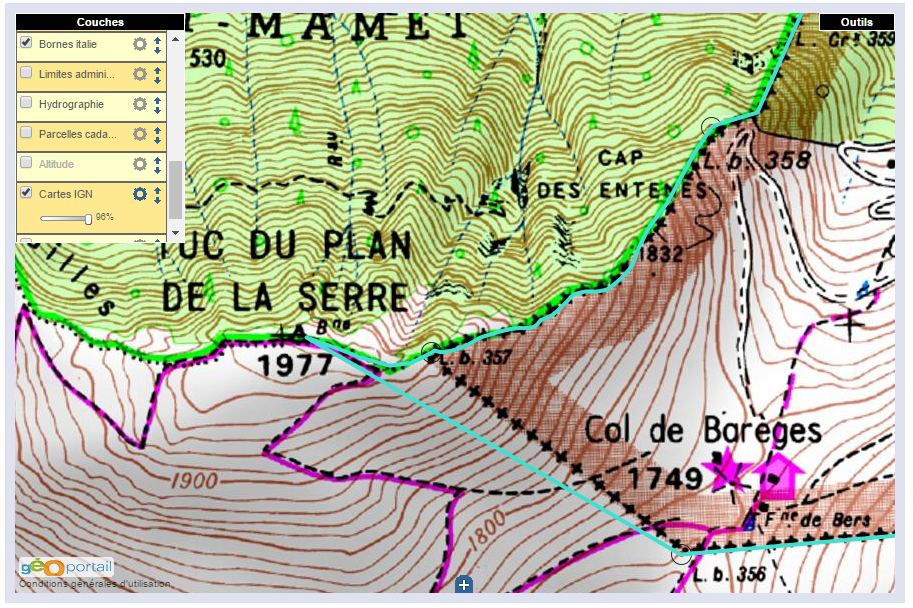
We have discussed this topic a lot of times: how the borderline between bm356 and 360 was meant to be, according to the Treaty of 1862, and how it was reconstructed (wrongly, I think) in the 1950-ies. See the previous post and this one.

(the blue line is the proposed new borderline, to my opinion the one meant in 1862)
In the 1950-ies, all borderpillars in this area had disappeared since long, leaving traces in only some rare cases. Thus the locations of almost every bordermarker (they had to be rebuilt) had to be reconstructed by matching the descriptions and distances in the Treaty with the terrain.
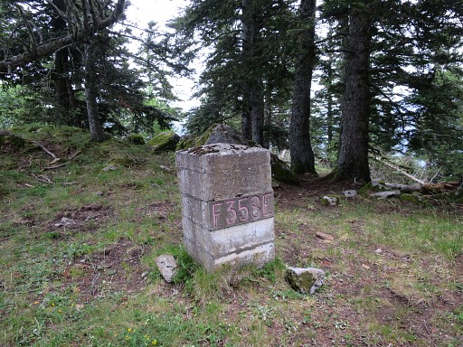
Jean Sermet writes in his “Journal de la restauration de l’abornement de la Haute Garonne” (1957) that the location of bm358 was however indisputable (at its current position) but he gives (in this article) no argument for that. If that location was indisputable, it fixes inevitably the locations of bm357 and 359 because the distances in between are described in the Treaty. But as said, he gives in his “Journal” no proof of his assertion.
We all know that Charles Darrieu is an great admirer of Jean Sermet, defending his work and decisions but always by presenting evidence, see his comments at the previous post. In this case, he has found the following phrase of Jean Sermet in the magazine Pyrénées n°131 – JUIL-SEP 1982 p 238: “Il n’y avait pas d’erreur pour le Cap des Entenés et d’autant moins que l’on y retrouva la base de l’ancienne borne 358 de 1863.” So: the remnants of the old bm358 were still present at that time! And that’s a real ‘smoking gun’ in this discussion.
Nowadays, there are no visible traces of a former bm at the location of bm358 but if it was the case in the 1950-ies, it solves and ends this dispute.
But I’m a bit stubborn and in my opinion my hypothesis fits best in the text of the Treaty of 1862. I haven’t found yet old topographic maps of the first half of the twentieth century or earlier. I think they would give the ultimate answer to this question. Or: the discovery of the original bordercross 359.


A written note on the map and his comment “the blue line is the new borderline, to my opinion the one meant in 1862”
Mail sent to Michel Molia on 01/16/2017:
How could such a ridiculous borderline be confirmed? A frontier which, from bordermarker 356, reaches the Tuc of Plan de la Serre, starts again in the opposite direction to follow the ridge and delimit a portion of “Camembert” a couple of meters away? No, the 1860-1862 negotiators left in a straight line from bordermarker 356 towards the Tuc. Once they had reached the divisoria, they established the bordermarker 357 and followed the crest line until the 359 (Treaty). On 12/17/2016, Eef Berns wondered about Bidaubus: “Who will defend the integrity of the French territory?” So, should this portion be added?
Therefore I wait to read the Report of the 2015 meeting of the CIP, signed by the Spanish and French delegates.
For now, the border appearing on the site of the CNIG reminds me of the vagueness of Google Earth.
I repeat: the installation of bordermarker 358 is that of General Callier, which was approved at a time when negotiations were bitter (see his letter as of 17 July 1866). The bordermarker 356 is next to the rock with the bars of Aragon and to the fleur-de-lys. Simply measure again. But errors, if any, have been approved by both countries and if there are corrections to be made, they must also be bilateral. Let us see if our delegate has negotiating talents!
In short, I regret not having the minutes or reports of the CMA or CIP meetings. Maybe one of you two will manage getting these documents?
Have a good day.