Tag Archives: Javier Sancho

Does bordercross 251 still exist?

Jacques Koleck (see previous post) surprised me by his pictures of bordercross 251, taken in 2008. We know that in the 19th century a cross 251 was engraved but – being replaced by the current borderstone 251 – I assumed that this cross was lost. Charles and Josette Darrieu searched for it but couldn’t find it. See this page on my website.

But Jacques shows that it still existed in 2008 and Charles Darrieu sent a picture of Javier Sancho, dating from june 2012. And I will gladly return to make my own pictures. But where is this cross located? Comparing the various pictures with Google Earth and my own footage results in a most likely spot. But first the pictures of Jacques:
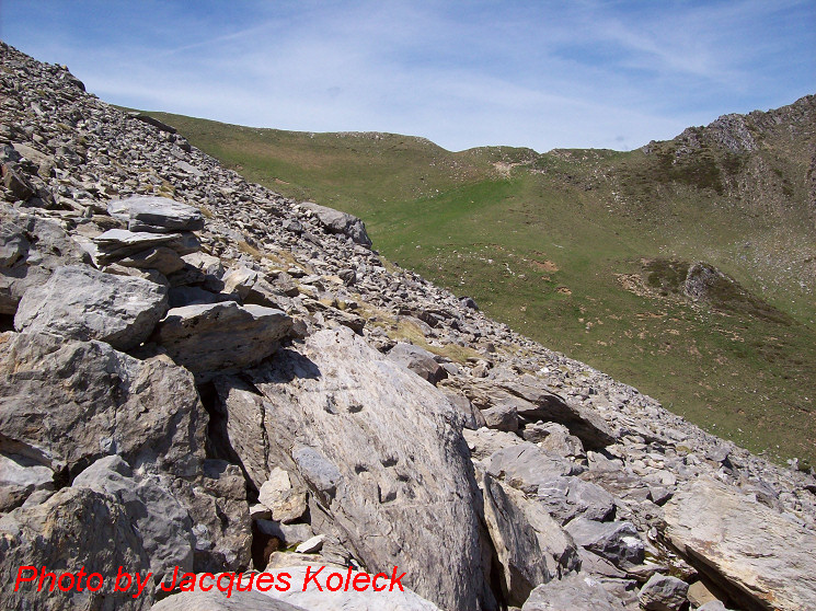
We’re looking to the west to the Port de Belhay where bm250 is located. Note the small darkgreen hilltop to the right which is visible at Google Earth. That makes it easy to determine a straight line (approx. west-east) from Port de Belhay to this cross somewhere in the rockslide.
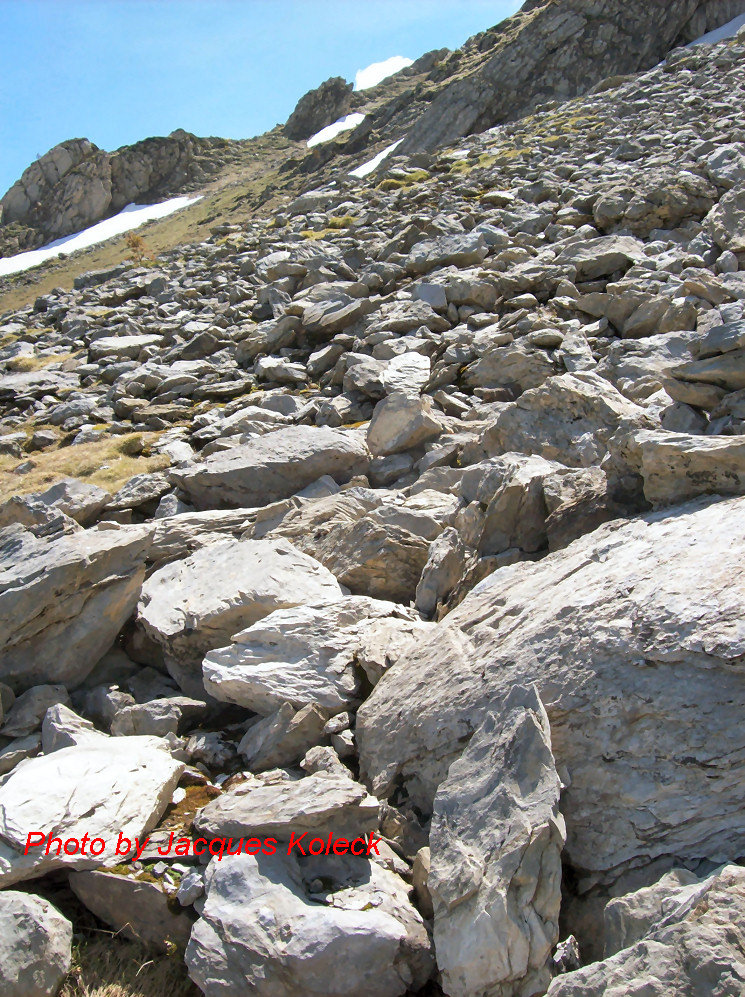
And on this second picture, we are necessarily looking south-east because of the other angle we see the cross but the picture gives no other clue. But the picture Charles sent me, made it possible to draw another line. And where those two lines intersect ……

But first an overview from Google Earth (note: compass direction reversed -> South is up). Remarkable: the yellow borderline (according to GE) is south of the actual bm251. A question for later: where is the official border?
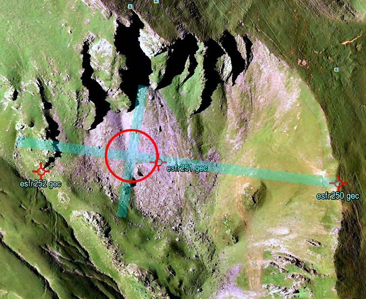
As said before, the crossing of the two straight lines should be the spot of cross 251. According to Google Earth it’s ± 50m to the SE (which is “NW” on this picture) of bm251. Jacques Koleck remembered that the cross was close to the old trail (not the red/white waymarked trail higher up) and on a “considerable” distance from bm251.
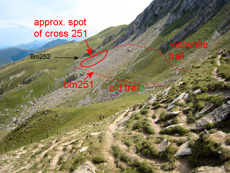
And finally an overview, as seen from Port de Belhay. Having watched this overview, Jacques Koleck added this information: “I think the cross is in the lower part of the circle, above the “old trail” and 20 meters of a large rock well visible on my photo with the Port de Belhay in the background. The cross “looks” east and is probably on a straight line between the stone marker 251 and the cross 252.” The 252-cross is just behind the lower end of the ridge, directly behind the circle.
A shorter route between bm271 and 272?

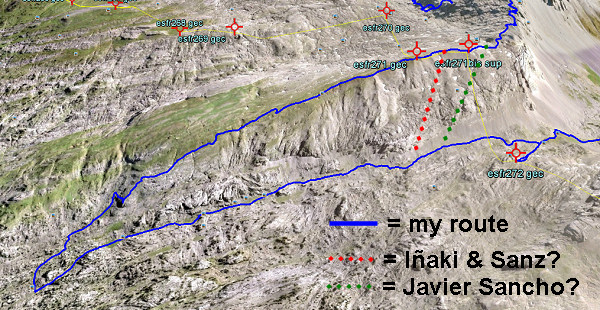
On 20120829 I had to make a large detour to get from bm271 to 272. A shorter descent seemed impossible because of the steepness of the rock-hillside underneath bm271. But I was surprised to read that Iñaki Vigor and Carlos Sanz (see literature) did use a more direct (cairns-waymarked) trail. They also thought it was far too steep. But they found at the saddle between the two hilltops (between bm271 and the former bm271bis) a cairns-trail which took  them without much problems to down below.
Also Javier et María-Jesús Sancho-Esnaola (see this previous post) took a short-cut but their starting point was the saddle east of bm297bis. They talk about following a cairns-trail, descending to the right down a gully (including some rock-scrambling), the route not always being obvious.

In both cases, they must have descended SW. Straight S is – according to the elevation lines – really too steep. Let’s draw it on this Google Earth-capture:

Conclusion: I have to return and check.

En busca de los hitos fronterizos

Which means: “in search of the bordermarkers”. I just received this book, mentioned in the previous post. I already learned that the Darrieu-couple are friends of Javier and María-Jesús Sancho-Esnaola. They assembled 6 volumes of information and pictures on the esfr-bordermarkers. That makes one jealous!

This ‘book’ is In fact a special edition of the Spanish magazine Pirineos.
Bibliographic data:
Pirineos Especial 9 – En busco de los hitos fronterizos : rutas por la Muga / Javier Sancho
El mundo de Pirineos. – junio 2010. – 147 p. / ISBN 978-84-8216-450-2

Javier Sancho describes 21 circular routes to bordermarkes – all along the esfr-border -with routes starting both in France and Spain. The maps could have been more elaborate but the photo’s are superb! I put the magazine on my reading list for Christmas to explore the details.


Spanish couple did all the bordermarkers

An unexpected google-find: a Spanish couple who has searched and photographed every bordermarker on the esfr-border. See this this newspaper-article. It reminds me of course of that other – French – couple: Charles et Josette Darrieu who did the same.
Javier Sancho and his wife even published a book on their project, for sale on a lot of on-line bookshops. I immediately ordered it.