Tag Archives: bm358

Jean-Paul Laborie again on television

Jean-Paul Laborie is a commissioner of the Pyrenean border committee. As such, he is popular with the media and has appeared several times in newspapers-articles or on television.

His latest appearance on television was part of a news-broadcast (Le 13 heures du samedi 23 mai 2020) on the French TF1-channel. Not as an actual news-item but as a human interest subject on the bordermarkers of the Pyrenees. The video contains a lot of drone-made aerial footage, I like that.

Les-bornes-frontière-de-Napoléon – Le 13 heures du samedi 23 mai 2020_TF1 from Eef Berns on Vimeo.

The video has four parts:
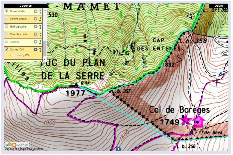
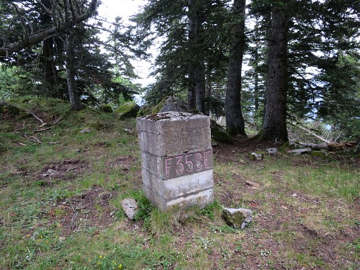
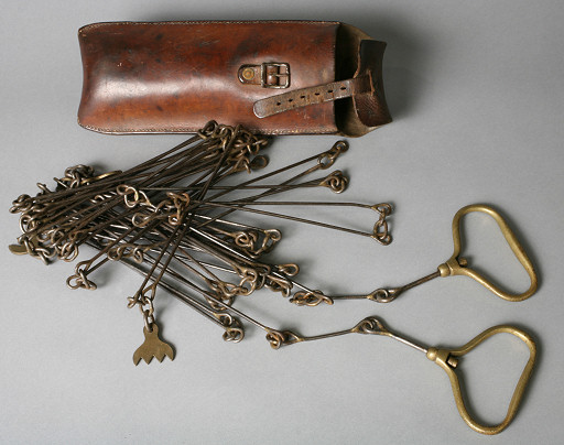
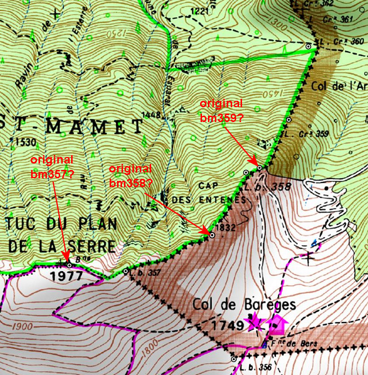
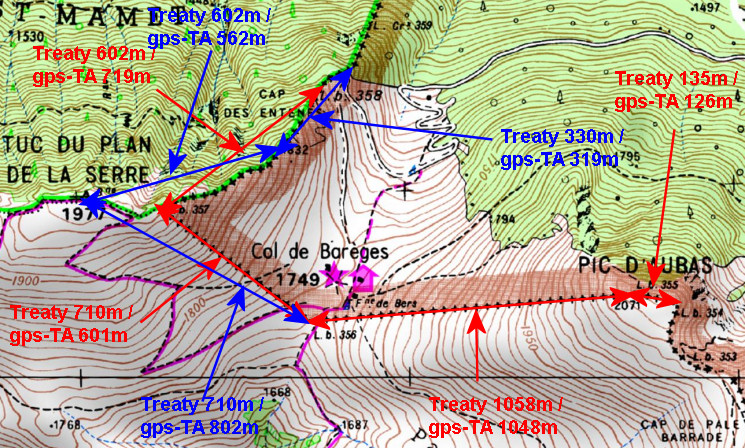
– part 1: Jean-Paul visits Col du Portillon (bm366) and Col de Barèges (bm356 and 358) and gives some explanations

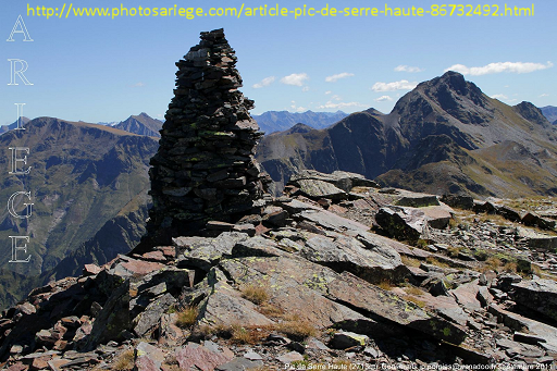
– part 2: a trip (without Jean-Paul) to the old mines of Bentaillou which are said to be close to bm420. In fact they are much closer to bm418/419 which is still a 2-hours walk from the mines. The guide points wrongly to a col (Portillon d’Albe) where there is no bordermarker and to a mountain top (Pic de Serre Haute) with a ‘borne’ visible. But that not a ‘borne frontière’ but a giant cairn.:

(Picture above borrowed from this webpage)

– part 3: two short visits to Llivia and Le Perthus

– part 4: Jean-Paul visits for the first time bm602 which is in a cave at the mediterranean coast. Bm602 is only accessible by boat or by swimming.

Traces of the old bm358: the ‘smoking gun’ of Charles Darrieu

We have discussed this topic a lot of times: how the borderline between bm356 and 360 was meant to be, according to the Treaty of 1862, and how it was reconstructed (wrongly, I think) in the 1950-ies. See the previous post and this one.

esfr-map-bm356-357-2015agreement-new-borderline
(the blue line is the proposed new borderline, to my opinion the one meant in 1862)

In the 1950-ies, all borderpillars in this area had disappeared since long, leaving traces in only some rare cases. Thus the locations of almost every bordermarker (they had to be rebuilt) had to be reconstructed by matching the descriptions and distances in the Treaty with the terrain.

Jean Sermet writes in his “Journal de la restauration de l’abornement de la Haute Garonne” (1957) that the location of bm358 was however indisputable (at its current position) but he gives (in this article) no argument for that. If that location was indisputable, it fixes inevitably the locations of bm357 and 359 because the distances in between are described in the Treaty. But as said, he gives in his “Journal” no proof of his assertion.

We all know that Charles Darrieu is an great admirer of Jean Sermet, defending his work and decisions but always by presenting evidence, see his comments at the previous post. In this case, he has found the following phrase of Jean Sermet in the magazine Pyrénées n°131 – JUIL-SEP 1982 p 238: “Il n’y avait pas d’erreur pour le Cap des Entenés et d’autant moins que l’on y retrouva la base de l’ancienne borne 358 de 1863.” So: the remnants of the old bm358 were still present at that time! And that’s a real ‘smoking gun’ in this discussion.

Nowadays, there are no visible traces of a former bm at the location of bm358 but if it was the case in the 1950-ies, it solves and ends this dispute.

gp-esfr358-20150705-photo02

But I’m a bit stubborn and in my opinion my hypothesis fits best in the text of the Treaty of 1862. I haven’t found yet old topographic maps of the first half of the twentieth century or earlier. I think they would give the ultimate answer to this question. Or: the discovery of the original bordercross 359.

The INSPIRE project: changing borderlines

Thanks to Michel Molia I discovered something amazing: the borderline between bm356 and 357 and between bm408 and 409 will most probably change.

The INSPIRE-project is a broad international attempt to synchronize geodata in the EU. One part consists of re-measuring and re-establishing the borderlines in bilateral agreement. Narrowing down to the ESFR-border: in 2015 an agreement was reached in the bilateral Commission Mixte d’Abornement in Toulouse.

You can see the result for the Pyrenees on this website showing the map with the borderline agreed-upon and the bordermarkers. The main purpose of the project is explained at this page
and specific to the ESFR-border on this webpage.

We read: “Commission mixte 2015. Une ligne frontière unique, bilatérale et numérique a été validée à la CMA de Toulouse en octobre 2015. Mais elle reste temporaire à proximité des bornes non encore mesurées précisément ainsi que de quelques sites où une mise en évidence contradictoire pourrait être produite.” So the newly measured (digitally) borderline is still provisionary because not all bordermarkers have been precisely measured yet.

There are many details still to study and to discuss here but let’s focus on two very interesting areas

Bm356-357
Last year I launched a new hypothesis how the borderline between bm356 and 357 was wrongly re-established in the 1950-ies (see this page). So I was happily surprised that the new borderline is exact as I thought it was meant in the Treaty of 1862 . Finally justice.

esfr-map-bm356-357-2015agreement-new-borderline

Bm408-409

I was even more surprised – but less happily – by the new borderline on this steep hillside. I have written about its intriguing story on this page. Conclusion then: the treaty leaves no doubt about the right borderline, the placement of four submarkers by Jean Sermet around 1965 served a diplomatic purpose but changed the borderline wrongly. Problem: no one knows nowadays where that new borderline was because 2 of the 4 submarkers are unfindable.
The CMA has aborted the borderline of Jean Sermet but has now its own diplomatic version somewhere in between the (supposed) Sermet-line and the Treaty-line. But it still violates the Treaty! In this case: justice needs to be done yet.


esfr-bm408-submarkers-2015agreement-with-explanation


To finish: the map which Michel Molia received from the IGN when he asked for information with some explanation by some IGN-official.

esfr-bm408-submarkers-2015agreement-with-explanation-from-ign-office

The explanation (added in black on the map) says that the Treaty was inprecise about where the source of the Ruisseau du Terme was. As said that is not true: in my opinion the text of the Treaty leaves no doubt about the course of the borderline.

Re-measuring distances between bm354 and 359

The Bayonne treaties are amazingly precise on the distances between the bordermarkers. Let’s focus on the array bm354-359. The treaty mentions:
bm354-355: 135m
bm355-356: 1058m
bm356-357: 710m
bm357-358: 602m
bm358-359: 330m

How was this measuring in the field done in the 19th century? Well, probably with a simple instrument called “chains”. If we google on surveyal-instruments on distance measuring, this is the dominant type.
land-surveying-instrument-chains

The big question: can we reproduce the above distances in a consistent way using digital tools like the elevation profile in Google Earth or using precise Digital Elevation Models (DEM) in other software?

As you know, I have serious doubts about the correct location of the current bordermarkers bm358 and 358 and thus the yet to find original bm359. Remember: all bordermarkers from bm333 to 407 were replaced in the 1950-ies because they had all disappeared since the 19th century. I posted already on this subject before. The distances mentioned in the Treaty can help us to test my hypothesis.

esfr-map-bm356-360-on-bm359-mystery- IGN-fr-map

The position of the three bm’s 354-355-356 are in my opinion indisputable. If we reproduce digitally their distances in between in a convincing way, then we can check if bm357 and 358 were placed on the right spots.

The easiest way is with Google Earth, using the elevation profile of the borderline between the bordermarkers. That gives the distances between the bm’s taking in account the elevation in between. But GE uses different DEM’s: whatever is available en most precise. So different stretches of the borderline can use different DEM’s, we just don’t know which one. And more disturbing: the profile-diagrams often show artefacts: unexplainable shifts:
google-earth-elevation-profile-example

A more consistent approach (but not necessarily more precise qua resolution) is using altitudes from NASA SRTM1-data  (downloaded with DEM1) and assigned to the gpx-tracks with GPS-Track-Analyse.NET. Let’s show the results on a map:

esfr-map-bm359-distances-remeasured-from-354-to-359
The red arrows and numbers refer to the distances between the existing bordermarkers. The blue arrows and numbers show the measurements of my hypothesis. As you can see: they make much more sense.  To finish: a table with all computations and remarks:

esfr-map-bm359-distances-remeasured-from-354-to-359-table

A new theory on bm359

The original bordercross 359 has never been found on the steep rugged hillside between bm358 and 360. I wrote a large article on this matter, concluding that the borderline on that hillside is not correct. Therefore bm359 should be searched at another spot but still on that steep hillside.
But a new hypothesis sprung to my mind recently. In short: both bm357 and 358 were reconstructed on the wrong places in the 1950-ies and the original bm359 was thus engraved at the beginning of the steep hillside, not in the middle. Let’s show it on the map:

esfr-map-bm356-360-on-bm359-mystery- IGN-fr-map

Let’s explain: after WWII all esfr-bordermarkers were surveyed and reconstructed when needed. Jean Sermet writes in his “Journal de la restauration de l’abornement de la Haute Garonne” (1957) that – in the Haute-Garonne – all borderpillars had disappeared in the well accessible parts of the borderline. In the replacing-process the original spots had to be established again, using the descriptions of the treaty of 1863 and in some rare cases the remains of the original masonry pillars.
The treaty of 1863 says that bm357 was placed at the “piton ou Tuc du Plan de la Serre” and that’s a well recognizable and plausible summit. BUT: the actual bm357 (from the 1950-ies) is constructed at the ridge ± 250m E downhill. You can see that perfectly on this picture.

gp-esfr357-20100911

One could say bm357 is placed at a sub-summit but definitely not at THE summit. Why? I can’t find any explication but there’s an account of a discussion on this subject in the report on “Abornement des pâturages espagnols en Haute-Garonne” from Jean Sermet on page 7. His Spanish counterpart M. Alija believed that bm357 should have been at the summit.
If we assume that the original bm357 was at the summit, it changes inevitably the position of bm358 and 359 because the treaty states explicitly the distances in between. Using the distance-calculator within Google Earth and counting the 602m along the ridge, the original bm358 would have been placed at a sub-summit (‘Es Antenes’ on the Catalonian topographic map, the treaty says: “au camp de Enténès”). Subsequently – after 330m – the original bm359 must have been engraved in a rock at the end of the ridge. And that’s a bit further – I think – than the new bm358. And that’s where the (very) steep hillside starts towards bm360.

Am I right? Well, it all fits much better in the treaty-description and in the topography and I’m pretty sure this is the way it was. Jean Sermet writes that the location of bm358 was indisputable (at its current position) but he gives no argument for that. In any case, I don’t see remains of the original mansonry bm358 at my pictures which would have been the very proof indeed.

In july Jan-Willem and I will return to the Haute-Garonne and see if we can find any confirmation. And to finish: the hypothesis on the Catalonian topographic maps:

esfr-map-bm356-360-on-bm359-mystery- ICCmap