Category Archives: News 2017

Marco Noris’ exhibition, now open to the public

Don’t miss it (I won’t): the wonderful exhibition of Marco Noris in the MuMe-museum in La Jonquera, 40km south of Perpignan. This Museu Memorial de l’Exili is a museum on the refugees who fled Spain after the civil war.
Marco has walked along the ESFR-border from Andorra to the Mediterranean in 25 days, visiting almost every bordermarker and making a (small) painting of each marker. His way of commemorating the border which was once a one-way threshold to freedom. The exhibition can be visited until 28 january 2018.

Marco Noris exhibition


International summit on the 408-submarkers

Yesterday was a historical day: a meeting at Cabane de Hérechet of Charles Darrieu and Michel Molia (French) with me (Dutch). We even had an international observer from Belgium: Henny.IMG_0975

(from left to right: Eef, Henny, Charles, MIchel)
Both frenchmen have covered all the existing bordermarkers on the ESFR-borderline and are puzzled – like me – by the fate of the 408-submarkers III and IV. They were installed about 50 years ago on a steeps hillside but are now unfindable. These missing markers are linked with an intriguing story of how a local conflict about tresspassing led to a change of the international borderline (see
http://www.grpdesbf.nl/esfr-html-markers-408-submarkers.html)

Goals of our meeting: meeting each other and of course a last joint effort to find the missing markers. We didn’t find them (as expected) but we sure had a very pleasant and interesting meeting.

Charles-MIchel-Eef

Conclusion: without a plan of the actual placement of the submarkers, there’s no clue where to search again after the numerous searches of us three.
There’s a French plan but buried somewhere in some archive but we now have a new link: a Spanish map kept in a Spanish archive.

Into the wild: avoid breaking your leg

corinne-gourgennetI was shocked in june by the email of Corinne Gourgeonnet, a passionate bordermarker-researcher in the “Pyrénées-Orientales”. She had broken her ankle on her way from Can d’Amunt to bm540. In a way still in safe area, on a trail regularly visited, while she could have been alone in the depths of the remote river-valleys of bm536 or 540.

I’m the least one to warn you because I often wander alone into the wild to find whatever remote bordermarker. But be prepared to be surprised by an injury like a broken ankle:
– if possible, don’t go alone
– if you do: tell someone of your itinerary
– bring your mobile telephone
– carry an emergency supply of water, food, bandages and painkillers
– take clothes with you to keep you warm and dry when needed
– know where you are

And Corinne? Don’t worry about her, she is brave and cheerful and is already making new bordermarker-trips.

Olivier and Patrick in action on Youtube

olivier-penaud-at-bm036Olivier Penaud is a devoted bordermarker-researcher in the Basque country. See his photo-blog. In a video-recording of the French tv-series “Des Racines et Des Ailes” (from 16:40 up to the end) we see him  showing us a few Basque bordermarkers and giving background information.


patrick-arderiu-at-bm602At the other side of the Pyrenees, the customs officer Patrick Arderiu takes us by boat to bm602 and tells about the annual reconnaissance of the bordermarkers.

An artist’s journey along the bordermarkers

I was surprised to read about the project of the artist Marco Noris from Barcelona: walking along the bordermarkers from Andorra to the Mediterranean and making a painting for each and every bordermarker. In fact it has already been accomplished on 11 september 2017 after a journey of 25 days, according to his detailed planning.

Marco-Noris

The artist describes his project (in the third person) in a way as only artists can: “During the walk, the artist will paint a work corresponding to each of the 198 milestones that mark the border. To walk and paint, joining together points along the border, as though balancing on that invisible line that divides in two that which is one, making visible what is invisible and opening up in this way a new stage for memory.

On his website, every day is nicely planned on a map and we read that he has had an extensive support team. The results of his project will be shown at the MuMe-museum in La Jonquera from 14 october to 28 january. I can’t wait to visit it, a top target for the winter.

Running the Llivia-circuit

It has been a plan for years: (trail)running around Llivia and visiting all the bordermarkers on the go. Why: for the fun of it and as a sporty challenge.

Today was the day and the route I was about to follow was my own GRPdesBF-one:
grpdesbf-llivia-01-45-maps01

Well, it took me 5:30h to complete the 25km. Many parts were unfit for running: too steep, too rocky or no trail at all. And when I could run, there were regularly interruptions to find the bordermarker, make a picture, to check where to proceed. So the average speed is low but the variation in speed was large. I was quite exhausted when I finished, also quite content. I think no one has ever done this.
IMG_0663 - Edited

The recording by Runkeeper can be seen at this page.

Visiting the Gorospil-cemetery

IMG_9661I’m back in the Pyrenees and today I visited the so-called Gorospil-cemetery: a graveyard of borderstones thrown from the Gorospil mountain-pass in the Basque-country. For whatever reason, bm75 and 76 were not quite popular between 1948 and 2003. Several successive generations were removed and tossed down the hillside to be dutifully replaced by officials with a new bordermarker.
It was Jacques Koleck who – in 2013 – first informed me of his findings: three old bordermarkers in the upper part of the stream of Haizagerrico, including an original bm76. Shortly afterwards, Javier Martínez Ruiz wrote me that he had in 2007 found the same bm76 as Jacques did and even found more bordermarkers down the stream, including an original bm75. This all triggered Anne Marie Bats and Bernadette Chasseur in 2014 to visit this ‘cemetery’ and they refound the markers of Jacques and Javier but also a ‘new’ bm75. In a few months, Jacques returned and he found an additional unmarked borderstone. See this page for the comprehensive story.
As you can read, I ‘m just standingd the shoulders of these devoted bm-investigators and I found easily all 6 bordermarkers standing erect in the stream-bed.

The 408-submarkers: Michel Molia’s quest

In the last weeks Michel Molia (from http://michelmolia.pagesperso-orange.fr/) has done a lot to find the missing submarkers 408III and IV. Without result but by doing so he could eliminate possible locations and narrowing down the terrain for future searches.
The submarkers 408-I to IV were placed in the 1960-ies in a change of the borderline to settle a borderdispute. The numbers III and IV are however unfindable. See this page for background-information.

But Michel is not the only one who has searched the area. Charles and Josette Darrieux undertook tough climbs from the Garonne up to the mountainridge and I myself did a couple of trips in the upper part.

Together we have crossed a large part of the area. Let’s put our gps-tracks together and see what’s left. You can check these tracks on a dynamic map.


bm408-submarkers-searches-image1In red: Michel’s tracks in the last weeks. In yellow some of my trips and in blue the tracks of the Darrieux. The orientation: up = west

bm408-submarkers-searches-image2Let’s first zoom in to the lower part where two streams (Ruisseau du Terme and la Goute de Réchèt come together for their final part to the Garonne. This could have been a possible spot for bm408-IV but Michel had already concluded that this is very unlikely considering the steepness of the terrain.

408-eef-7
Picture of Michel of the confluence of the two streams. They are small streams as you can see.

bm408-submarkers-searches-image3This is the upper part with possible locations not far from the Cabane de Hérechet where streams (re)appear and merge.

bm408-submarkers-searches-image4Zoom-in of the middle part. There are two streams: one which originates above the cabane (it draws its water from) and one which starts to the left of the cabane. Michel supposes that this second one could be the continuation of the stream which springs at bm408-I and supposedly goes underground to reappear here. Hij would like to test that with color-marker like Norbert Casteret did to establish the source of the Garonne.
They merge here into the Gout de Hérechet.  Might have been a logical place for a submarker. However: no bordermarker around here.

bm408-submarkers-searches-image5To finish: the upper part. My own theory focusses on this area but as you can see, it has been searched quite thoroughly. It remains a mystery.


Traces of the old bm358: the ‘smoking gun’ of Charles Darrieu

We have discussed this topic a lot of times: how the borderline between bm356 and 360 was meant to be, according to the Treaty of 1862, and how it was reconstructed (wrongly, I think) in the 1950-ies. See the previous post and this one.

esfr-map-bm356-357-2015agreement-new-borderline
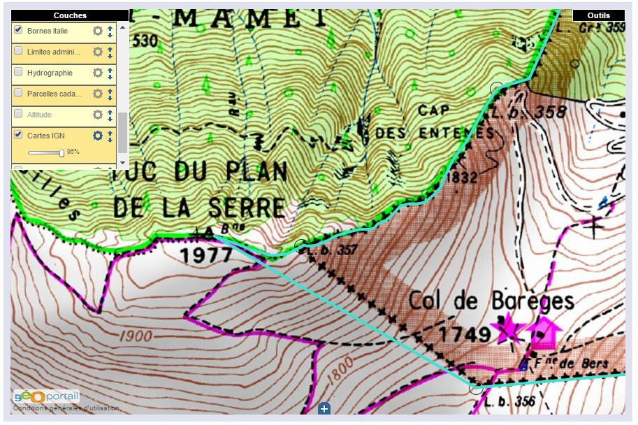
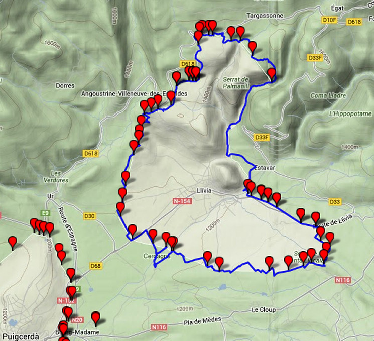
(the blue line is the proposed new borderline, to my opinion the one meant in 1862)

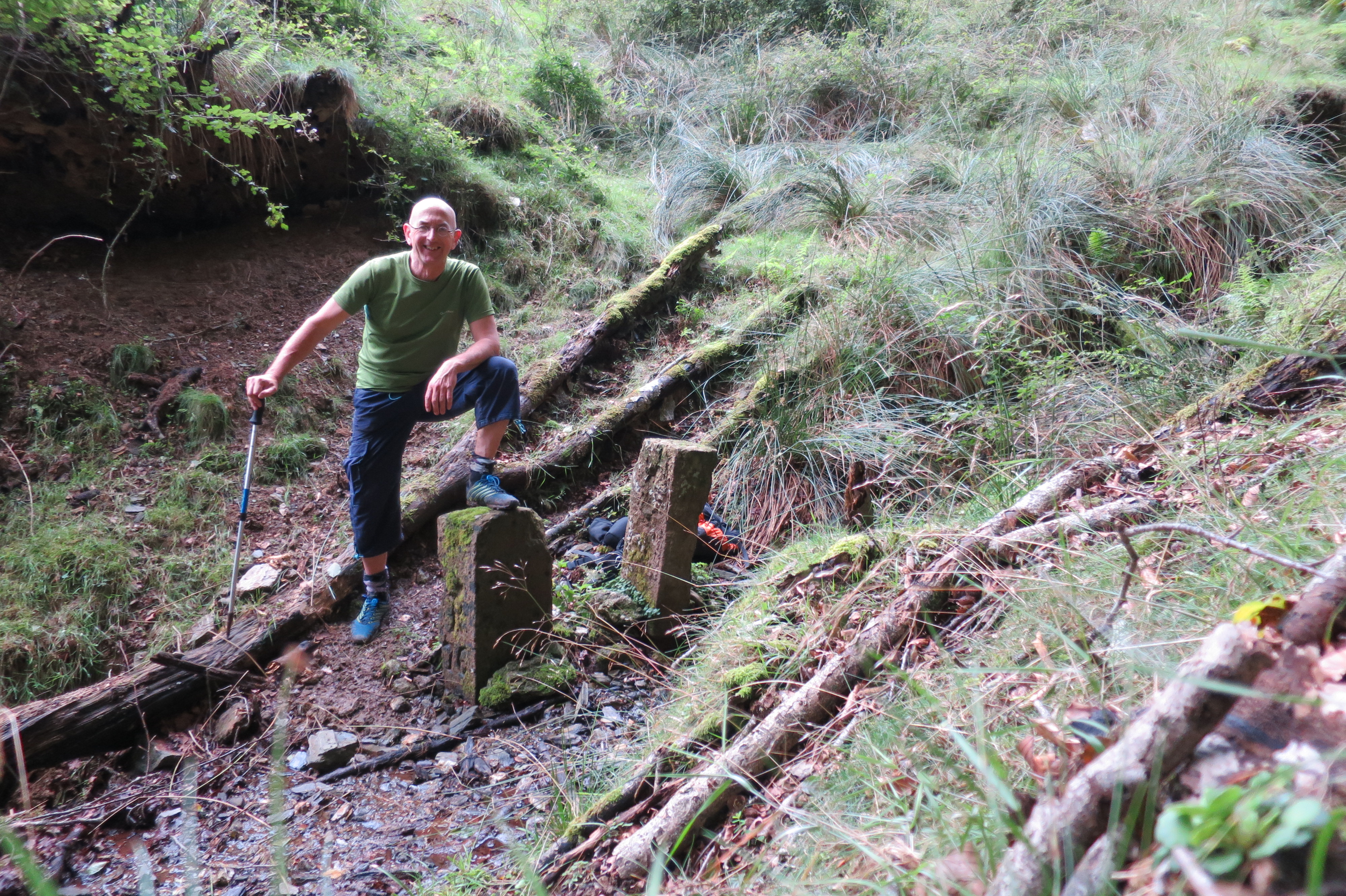
In the 1950-ies, all borderpillars in this area had disappeared since long, leaving traces in only some rare cases. Thus the locations of almost every bordermarker (they had to be rebuilt) had to be reconstructed by matching the descriptions and distances in the Treaty with the terrain.

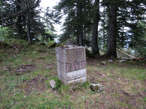
Jean Sermet writes in his “Journal de la restauration de l’abornement de la Haute Garonne” (1957) that the location of bm358 was however indisputable (at its current position) but he gives (in this article) no argument for that. If that location was indisputable, it fixes inevitably the locations of bm357 and 359 because the distances in between are described in the Treaty. But as said, he gives in his “Journal” no proof of his assertion.

We all know that Charles Darrieu is an great admirer of Jean Sermet, defending his work and decisions but always by presenting evidence, see his comments at the previous post. In this case, he has found the following phrase of Jean Sermet in the magazine Pyrénées n°131 – JUIL-SEP 1982 p 238: “Il n’y avait pas d’erreur pour le Cap des Entenés et d’autant moins que l’on y retrouva la base de l’ancienne borne 358 de 1863.” So: the remnants of the old bm358 were still present at that time! And that’s a real ‘smoking gun’ in this discussion.

Nowadays, there are no visible traces of a former bm at the location of bm358 but if it was the case in the 1950-ies, it solves and ends this dispute.

gp-esfr358-20150705-photo02

But I’m a bit stubborn and in my opinion my hypothesis fits best in the text of the Treaty of 1862. I haven’t found yet old topographic maps of the first half of the twentieth century or earlier. I think they would give the ultimate answer to this question. Or: the discovery of the original bordercross 359.

The INSPIRE project: changing borderlines

Thanks to Michel Molia I discovered something amazing: the borderline between bm356 and 357 and between bm408 and 409 will most probably change.

The INSPIRE-project is a broad international attempt to synchronize geodata in the EU. One part consists of re-measuring and re-establishing the borderlines in bilateral agreement. Narrowing down to the ESFR-border: in 2015 an agreement was reached in the bilateral Commission Mixte d’Abornement in Toulouse.

You can see the result for the Pyrenees on this website showing the map with the borderline agreed-upon and the bordermarkers. The main purpose of the project is explained at this page
and specific to the ESFR-border on this webpage.

We read: “Commission mixte 2015. Une ligne frontière unique, bilatérale et numérique a été validée à la CMA de Toulouse en octobre 2015. Mais elle reste temporaire à proximité des bornes non encore mesurées précisément ainsi que de quelques sites où une mise en évidence contradictoire pourrait être produite.” So the newly measured (digitally) borderline is still provisionary because not all bordermarkers have been precisely measured yet.

There are many details still to study and to discuss here but let’s focus on two very interesting areas

Bm356-357
Last year I launched a new hypothesis how the borderline between bm356 and 357 was wrongly re-established in the 1950-ies (see this page). So I was happily surprised that the new borderline is exact as I thought it was meant in the Treaty of 1862 . Finally justice.

esfr-map-bm356-357-2015agreement-new-borderline

Bm408-409

I was even more surprised – but less happily – by the new borderline on this steep hillside. I have written about its intriguing story on this page. Conclusion then: the treaty leaves no doubt about the right borderline, the placement of four submarkers by Jean Sermet around 1965 served a diplomatic purpose but changed the borderline wrongly. Problem: no one knows nowadays where that new borderline was because 2 of the 4 submarkers are unfindable.
The CMA has aborted the borderline of Jean Sermet but has now its own diplomatic version somewhere in between the (supposed) Sermet-line and the Treaty-line. But it still violates the Treaty! In this case: justice needs to be done yet.


esfr-bm408-submarkers-2015agreement-with-explanation


To finish: the map which Michel Molia received from the IGN when he asked for information with some explanation by some IGN-official.

esfr-bm408-submarkers-2015agreement-with-explanation-from-ign-office

The explanation (added in black on the map) says that the Treaty was inprecise about where the source of the Ruisseau du Terme was. As said that is not true: in my opinion the text of the Treaty leaves no doubt about the course of the borderline.