Category Archives: News 2015

Touching The Stone

I just finished a 6-days backpacking expedition from Guzet-Neige to Latour-Carol. Main goal: a reconnaissance of my intended GRPdesBf-route through Andorra. It was quite tough with very strong gales up on the mountains in the last few days.
This picture: at bordermarker 427 (eastern tripoint of Andorra) with me touching the stone.

IMG_2695

Re-measuring distances between bm354 and 359

The Bayonne treaties are amazingly precise on the distances between the bordermarkers. Let’s focus on the array bm354-359. The treaty mentions:
bm354-355: 135m
bm355-356: 1058m
bm356-357: 710m
bm357-358: 602m
bm358-359: 330m

How was this measuring in the field done in the 19th century? Well, probably with a simple instrument called “chains”. If we google on surveyal-instruments on distance measuring, this is the dominant type.
land-surveying-instrument-chains

The big question: can we reproduce the above distances in a consistent way using digital tools like the elevation profile in Google Earth or using precise Digital Elevation Models (DEM) in other software?

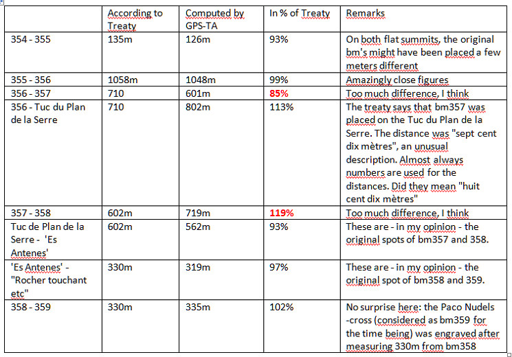
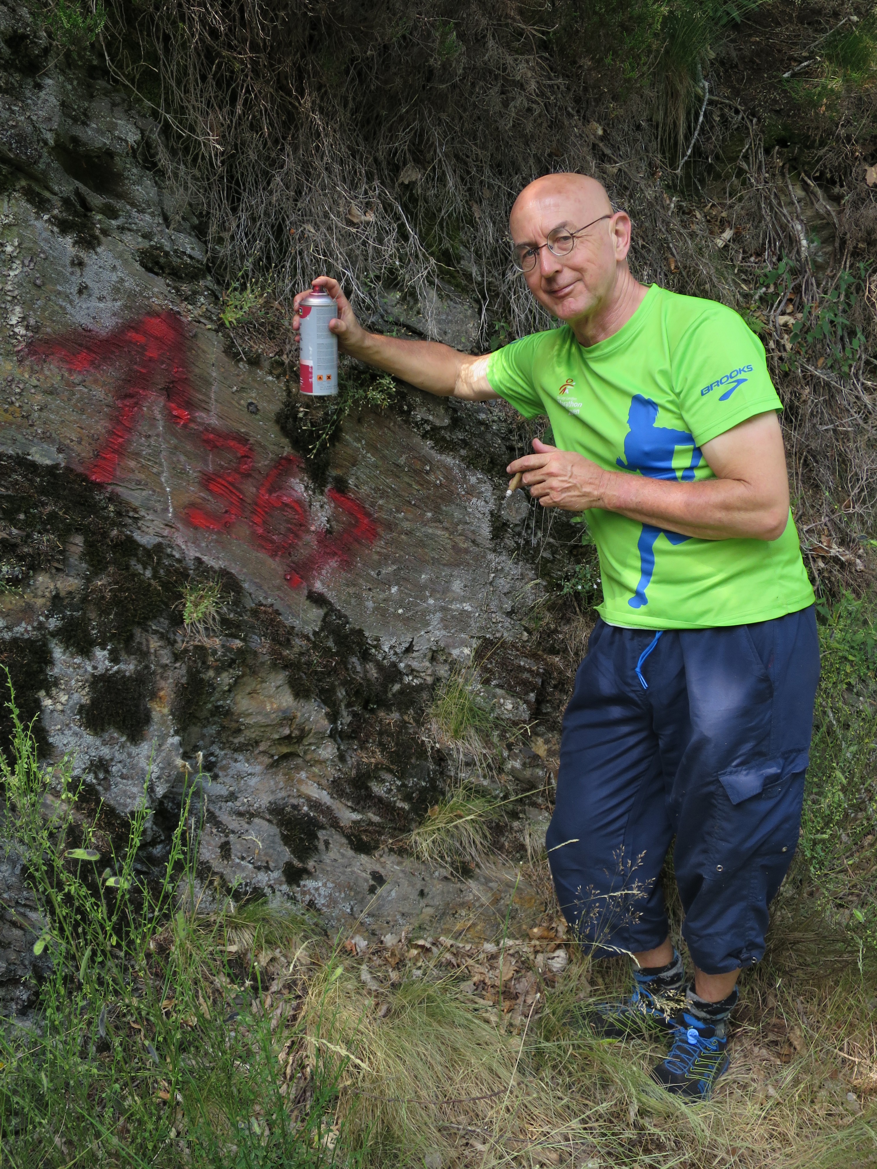
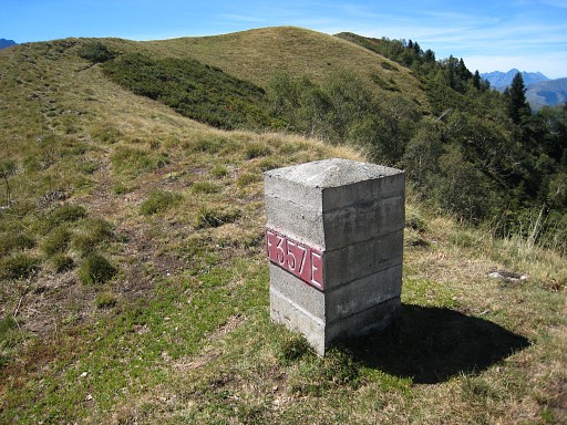
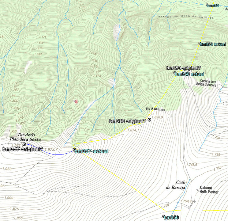
As you know, I have serious doubts about the correct location of the current bordermarkers bm358 and 358 and thus the yet to find original bm359. Remember: all bordermarkers from bm333 to 407 were replaced in the 1950-ies because they had all disappeared since the 19th century. I posted already on this subject before. The distances mentioned in the Treaty can help us to test my hypothesis.

esfr-map-bm356-360-on-bm359-mystery- IGN-fr-map

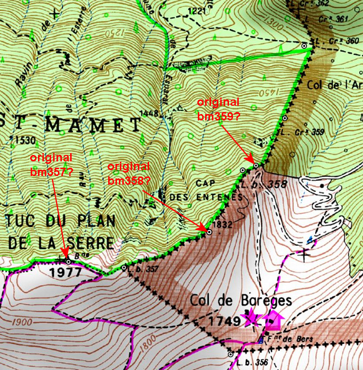
The position of the three bm’s 354-355-356 are in my opinion indisputable. If we reproduce digitally their distances in between in a convincing way, then we can check if bm357 and 358 were placed on the right spots.

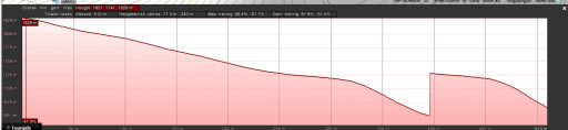
The easiest way is with Google Earth, using the elevation profile of the borderline between the bordermarkers. That gives the distances between the bm’s taking in account the elevation in between. But GE uses different DEM’s: whatever is available en most precise. So different stretches of the borderline can use different DEM’s, we just don’t know which one. And more disturbing: the profile-diagrams often show artefacts: unexplainable shifts:
google-earth-elevation-profile-example

A more consistent approach (but not necessarily more precise qua resolution) is using altitudes from NASA SRTM1-data  (downloaded with DEM1) and assigned to the gpx-tracks with GPS-Track-Analyse.NET. Let’s show the results on a map:

esfr-map-bm359-distances-remeasured-from-354-to-359
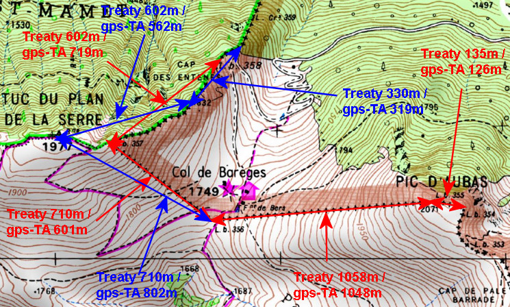
The red arrows and numbers refer to the distances between the existing bordermarkers. The blue arrows and numbers show the measurements of my hypothesis. As you can see: they make much more sense.  To finish: a table with all computations and remarks:

esfr-map-bm359-distances-remeasured-from-354-to-359-table

Here comes Jean-Paul again

Jean-Paul Laborie is one of the border-commissioners of the Pyrenees. As such he doesn’t quite seek shelter in the shadow. Frequently he appears in newspapers or on tv. His latest appearance is in a short documentary on “Les bornes frontières entre la France et l’Espagne” telling about the bordermarkers (this is bm152) and the peculiar ‘Pays Quint’:  Spanish territory inhabited by French farmers. One thing is puzzling: at some point (at 2.05′) he seems to state that the border between two bordermarkers is a straight line which is untrue.

video-cap-sud-ouest-les bornes-frontieres

The Pays Quint is also a small subject in a longer documentary on “Les 100 lieux qu’il faut voir – Pays Basque” on France 5. In five minutes (from 30′ to 35′) bm139 is shown and the Pays Quint explained.

video-les-100-lieux-etc-pays-basque

The bordercross 367 is not easy to find – even with a gps – hidden as it is in the forest. So I decided to help you with some waymarking by cairns and painting from the dirtroad into the forest. And while spraying the paint, I felt like a graffiti-artist. I think I missed my real vocation somewhere along the line of my life.
IMG_1924

And this waymarking is also a kind of tribute to Josette Darrieu – the wife of Charles Darrieu – who sadly passed away in april of this year. She was the one who – in 2007 – discovered this very bordercross under a layer of moss and earth.

And all this is part of a few days of intense bordermarker-research around Bossòst, searching again for the last unfindable bordermarkers: bm359, bm408 III & iV and 364.

The Basques can go ahead

There are a lot of Basques who want to visit all esfr-bordermarkers on the Basque territory and that implies walking from bordermarker 1 to 272. On my website I completed the 13 GRPdesBF-stages which will help them along the way, providing all the maps and directions they need.

esfr-map-basque-country-with-bm-indication

And – in this update – there is much more new: see the update-log.

A new theory on bm359

The original bordercross 359 has never been found on the steep rugged hillside between bm358 and 360. I wrote a large article on this matter, concluding that the borderline on that hillside is not correct. Therefore bm359 should be searched at another spot but still on that steep hillside.
But a new hypothesis sprung to my mind recently. In short: both bm357 and 358 were reconstructed on the wrong places in the 1950-ies and the original bm359 was thus engraved at the beginning of the steep hillside, not in the middle. Let’s show it on the map:

esfr-map-bm356-360-on-bm359-mystery- IGN-fr-map

Let’s explain: after WWII all esfr-bordermarkers were surveyed and reconstructed when needed. Jean Sermet writes in his “Journal de la restauration de l’abornement de la Haute Garonne” (1957) that – in the Haute-Garonne – all borderpillars had disappeared in the well accessible parts of the borderline. In the replacing-process the original spots had to be established again, using the descriptions of the treaty of 1863 and in some rare cases the remains of the original masonry pillars.
The treaty of 1863 says that bm357 was placed at the “piton ou Tuc du Plan de la Serre” and that’s a well recognizable and plausible summit. BUT: the actual bm357 (from the 1950-ies) is constructed at the ridge ± 250m E downhill. You can see that perfectly on this picture.

gp-esfr357-20100911

One could say bm357 is placed at a sub-summit but definitely not at THE summit. Why? I can’t find any explication but there’s an account of a discussion on this subject in the report on “Abornement des pâturages espagnols en Haute-Garonne” from Jean Sermet on page 7. His Spanish counterpart M. Alija believed that bm357 should have been at the summit.
If we assume that the original bm357 was at the summit, it changes inevitably the position of bm358 and 359 because the treaty states explicitly the distances in between. Using the distance-calculator within Google Earth and counting the 602m along the ridge, the original bm358 would have been placed at a sub-summit (‘Es Antenes’ on the Catalonian topographic map, the treaty says: “au camp de Enténès”). Subsequently – after 330m – the original bm359 must have been engraved in a rock at the end of the ridge. And that’s a bit further – I think – than the new bm358. And that’s where the (very) steep hillside starts towards bm360.

Am I right? Well, it all fits much better in the treaty-description and in the topography and I’m pretty sure this is the way it was. Jean Sermet writes that the location of bm358 was indisputable (at its current position) but he gives no argument for that. In any case, I don’t see remains of the original mansonry bm358 at my pictures which would have been the very proof indeed.

In july Jan-Willem and I will return to the Haute-Garonne and see if we can find any confirmation. And to finish: the hypothesis on the Catalonian topographic maps:

esfr-map-bm356-360-on-bm359-mystery- ICCmap

“La bornite”: an infectious disease

I stumbled on a website made by Michel Molia who – with some friends – wants to discover the bordermarkers between France and Spain. He describes wittily in the prologue their interest as an infectious disease and he proposes the name “la bornite”. He himself has become a severe case.

website-michel-molia
Their homebase is Bayonne and so far they have covered a lot of the 720 bordermarkers – including bm602! – but most of them in the western half. They started in 2013. What strikes me is that they seem to have started from scratch, ignorant of the available information (on the internet). There’s hardly any reference to any sources or using waypoints from others or whatsoever . The website seems in the first place a cheerful account of a friendship’s-project meant for the friends themselves. And I like that, that’s how I started many, many years ago with my own friends along the dutch-belgian border. (see this webpage).

Cerdagne in the spring

IMG_1302I spent a few days in the Cerdagne, redoing the bordermarkers 444-505. April is perfect for searching and photographing bordermarkers. The weather is improving, the days are longer and while nature is blossoming en the first leaves are appearing, the undergrowth is still in winter’s rest. That makes finding and photographing bordermarkers a lot easier.

But in this spring symphony there was one false note: catalonian separatists having desecrated a defenseless bordermarker.

New update of “The bordermarkers of the Pyrenees”

pic-of-grpdesbf-homepageI’m proud to announce an update: again several more grpdesbf-stages (now from bm091 to 212) have been worked out in full detail, providing the maps and directions you need to walk the GRPdesBF.


New update of “The bordermarkers of the Pyrenees”

pic-of-grpdesbf-homepageI’m proud to announce an update: seven more stages of my coast-to-coast GRPdesBF-trail have been worked out in full detail, providing the maps and directions you need to walk the GRPdesBF.

And there are more additions: check the update-log.