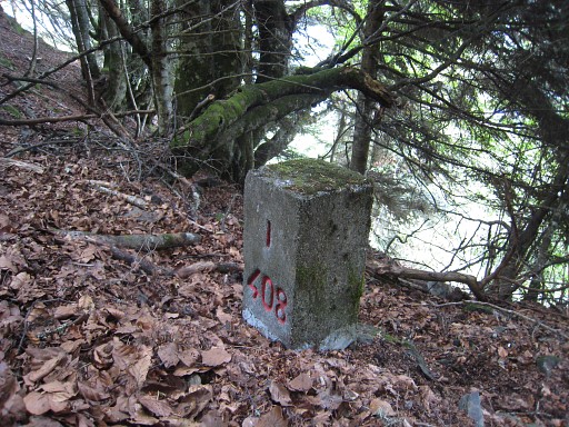
Around 1964 a set of 4 submarkers (408 I to IV) were placed high above the river Garonne near the village of Fos. From 1959 onwards, Spanish foresters had tresspassed between bm408 and 409 the Ruisseau du Terme, claiming that another stream – to the north – was meant as the borderline in the 1862-treaty.
From the beginning, the border-commissioners Jean Sermet and his Spanish colleague Alija were inclined to that theory which led ultimately to the placement of the four submarkers.
The available documents (kindly provided by the Darrieu’s) tell a fascinating story. My conclusion: Sermet & Alija were wrong! Judge for yourself on this (elaborate) special page


I just looked at your account of the submarkers of 408.. Interesting. But now permit this retired lawyer to confuse the matter further: the meaning of “error” or “mistake” actually changes!
There is a principle of international law called “acquisitive prescription” which holds that territorial sovereignty shifts with actual practice. Suppose (for the sake of simple illustration) a treaty between 2 states defines their shared border as X degrees north latitude, but in the course of settlement people become confused as to where that really is on the ground, and Jean who lives on plot A registers his car with the state to the north even though he actually resides to the south of the line of latitude, while his neighbor to the east Juan pays property taxes to the state to the south even though his plot B is actually to the north of the line of latitude. Under the doctrine of acquisitive prescription, if the matter of private habit had gone for some years, unchallenged or undefended by the respective states, the border itself would legally change. In other words, ‘de facto’ ripens into ‘de jure,’ even though the treaty and statutes still define the border as latitude X….There’s a nice discussion from your countryman Prof. Lesaffer (Univ. Tilburg) in European Journal of International Law 16:1 (2005). The point is even stronger when the ‘mistake’ is made not by private habit but by affirmative action under color of state authority, so that if officials from both governments place boundary markers, what would have been ‘mis’-placement originally turns into the very definition of ‘correct’ placement.
Thanks for your reaction. So: that “acquisitive prescription”-principle could help Spain to claim for eternity the extra terrritory delimitated by the 408-submarkers (if France wished to revert the decision of Sermet & Alija but I think no one cares). France could – in that case – put forward that apparently – before the foresters started their tresspassing – there wasn’t any confusion between both communities on eitherside of the border where the esfr-border was.
Yes, that would be my understanding: It may have been French before but its Spanish now.. Of course, like everything else in law–but especially international law–it is not hard and fast. But you see it when there is honest confusion over borders… You might be interested in knowing that within the US the principle is sometimes applied to the (fairly rare) situations of disputes over boundaries of the individual states (on the fiction that they are like independently sovereign entities.) In the 1980s, in extreme northeastern California a California Highway surveyor had noted that a sign for an Oregon State Park appeared to be 10 meters or so inside California and had it dug up and moved. Oregon put it back, and a small ‘war’ ensued. (No shooting.) There was a small settlement nearby, with the question of to which county one paid one’s property taxes, which driver’s license one was supposed to have, and where to register your car, affected about a dozen people. By satellite, it was clear that the Oregonians had “invaded” California. Now, this is a pretty desolate area; it is basically desert. But there are enough issues of taxation and possibly mineral rights that the two states actually went to the US Supreme Court, which applied acquisitive prescription to rule that, south of latitude 42 or not (the official definition of the line), it now belongs to Oregon.
What all that means for the Ems/Eems dispute, I don’t know. It has not been heavily reported on here. I was inspired to look at your old ‘grenspaal’ site, and enjoyed it a great deal. I don’t speak Dutch but lived in Germany for a while so was able to get much of your narrative…..(It makes us think about border formation generally; culture and language typically exist in a continuum rather than by sharp break, so why is the line here and not there, etc.) It wanders, but not unreasonably so. Given how confusing and apparently strange European borders can be (e.g., Baarle -Nassua/Hertog!)–and especially considering how confusing it is to look at a map of pre-Bismarck Germany– I was struck by how much of the Dutch border with Prussia and Hannover is made up of relatively straight line segments.
Best regards