Category Archives: News 2012

A new update of my main website: www.grpdesbf.nl

See for the update-details: http://www.grpdesbf.nl/esfr-html-miscellania-updatelog.html

The ultimate highlight of last year was swimming to bm602:

I have now visited every bordermarker at least twice with at least one year difference.

Will that be a farewell to the Pyrenees? Not at all. There will always be a reason – at least for old times’ sake – to travel to these cherished mountains and their bordermarkers. My next trip will be soon: see https://www.grpdesbf.nl/esfr-html-miscellania-to-do.html

Alain Gillodes: all bordermarkers done

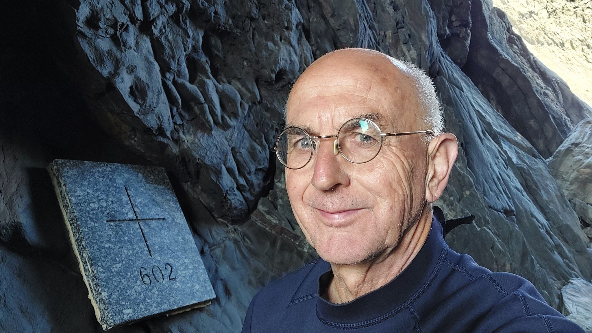
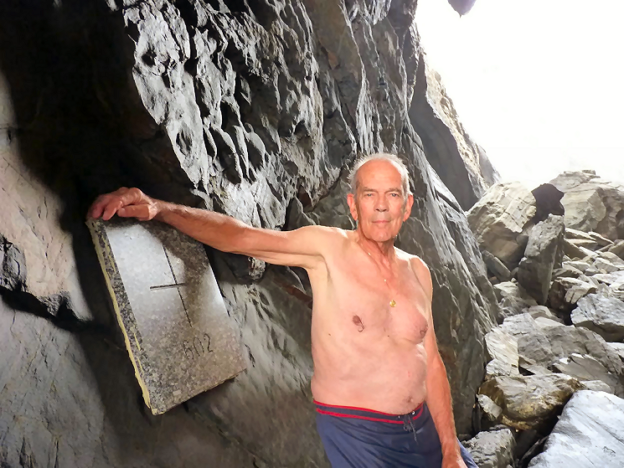
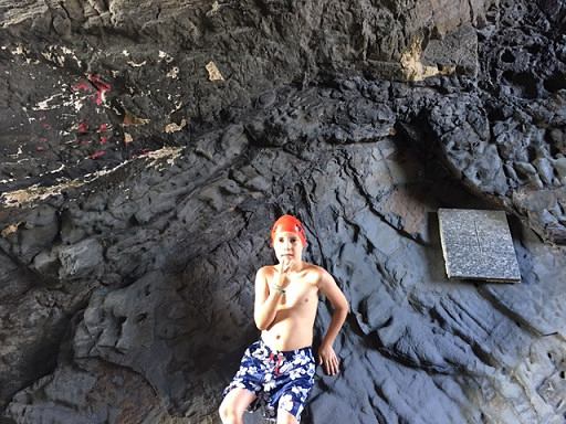
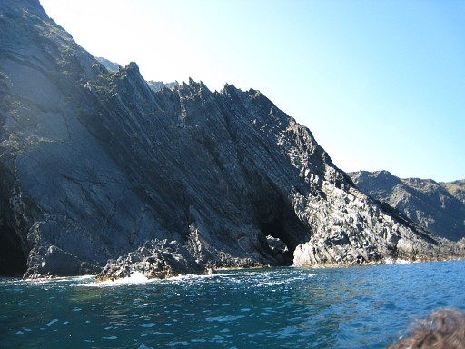
Alain Gillodes reported to me that on June 19th, 2021, he visited his very last esfr-bordermarker. It is perhaps the most iconic one: no. 602 in the Cova Forada, a cave at the Mediterranean coast, accessible only by boat or swimming.

It was a birthday present of his two sons who hired a boat to bring him to the cave. But the sea was quite rough,

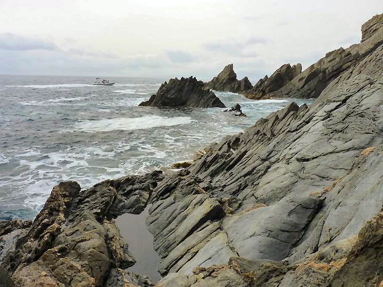
too rough to get close to the cave.

The only way to reach the cave was by swimming – together with one of his sons – and it took 3 trials to get safely into the cave.

It was with immense joy that I could finally photograph this last marker“, wrote Alain.

With bm602, Alain has completed his quest of visiting all bordermarkers on the French-Spanish border. He started in 2015 and his pictures can be seen on this page and the interesting accounts of every trip on this one. He is not afraid of a dull bm-afterlife. As an enthusiastic cycler, he has conquered 6800 cols worldwide and he wants to reach the number of 7000.

By completing his quest, Alain has entered the Gallery of Honour of men and women who have covered each and every esfr-bordermarker. This Gallery  features (as far as I have information):

1.  Javier and María-Jesús Sancho-Esnaola
2.  Charles and Josette Darrieu
3.  Jacques Koleck
4.  Myself
5.  Michel Molia
6.  Alain Gillodes

And there are some people working hard on reaching that goal: Carlos and Conchita Roca (approximately 75% done) and Corinne Gourgeonnet (who wants to finish this year). Good luck to them.

Corinne & Arthur: swimming to bm602!

Bm602 can’t be reached by foot. This very last bordercross is hidden in a cave at the Mediterranean coast between Portbou and Cerbère. In 2011 we rented a boat with a boatsman to get there and Serge Poncet peddled with a canoe from Cerbère while the mountaineer Lionel Daudet descended along the steep rockwall to the waterlevel. The cave is in fact a tunnel as the following picture shows.

esfr-trip-20110521-photo25

There has been only one man (Cayetano) who reached the cave by swimming as far as I know.  Until now….because Corinne Gourgeonnet and her little son Arthur undertook the same adventure on August 2th 2018. From Portbou they followed the trail along the coast as far as they could and then started swimming.

esfr-map-bm600-602-googleearth-swimming-to-bm602-by-corinne-and-arthur

And that’s not something to consider lightly: it implies swimming 700m to the cave and 700m back. To remind you: Arthur is only 9 years old but – as his mother wrote me – a good swimmer.

gp-esfr602-20180802-with-arthur-photo-by-corinne-gourgeonnet

And the young Arthur may behold the future of our bordermarker-interest. Corinne is since a few years an impassioned searcher of bordermarkers and Arthur joins her regularly and who knows ….

gp-esfr023-024-2018-unnumbered-cross-in-between-with-arthur-photo-by-corinnegourgeonnet

Arthur is his habitat to be perhaps. Picture taken this spring in the Basque country between bm022 and 023.

Bm271bis: a nightmare

Well, it’s a nightmare for Jesús Murueta. He has ‘done’ the esfr-bordermarkers 1-272 in the years 2000-2003, finding all these bordermarkers or getting an old picture of the few markers which are are lost. See this post for his story and to download his extensive account.

There’s one exception: bm271bis. It was a bordercross on the isolated and rough ridge of Añelarra near Pic d’Anie.  It has long been reported (on the French topographic maps) as being destroyed and no one in the last decennia has found any trace of it and we have NO old pictures. This keeps haunting  Jesus Murueta: a picture would fulfill his bordermarker-quest. Who can help him?

But there’s an important question: what was in fact the location of bm271bis? The esfr-border follows in this part of the karst-plateau a a zigzag-line with a straight part on the Añelarra-ridge for a few hundred meters.Let’s show it on this Google-Earth map:

The Añelarra-ridge has two summits. Bm271 is at the western summit and nowadays we find a geodesic  marker of Navarra, close to it (with D.F.N. on it = Diputación Foral de Navarra). That makes sense. The second summit is at ± 240m to the east and could make a logical location for bm271bis. Here we find today an iron plaque with the contour of Navarra and a large cairn.

But the topographical and historical evidence is different! The original treaty says that bm271bis is 360 meters from bm271 on the same ridge. But we have to acknowledge that the distances between the previous bordermarkers 262-271 – as mentioned in the treaty – are often unreliable.
The location of bm271bis on the IGN-maps is ± 310m from bm271 when following the ridge.  And that position makes more sense.  The ridge descends and bends slowly in the direction of Pic d’Anie. It’s a logical/natural place for the borderline to bend southwards and descend towards Col d’Anaye. Let’s zoom in:

I have to return and do a new search, now focussed on the lower half of the red circle. The upper half and center of the circle, I searched thoroughly on this trip.

TopoPirineos: a free and detailed map of the Pyrenees

I was surprised to learn from Charles Darrieu that there is an extensive and free hikingmap of the Pyrenees. It’s built to be used it in Garmin-software (Mapsource / Campbase) and on Garmin-gps-devices. You can download it from http://topopirineos.blogspot.fr/

Installing this map-software wasn’t that straightforward (at my computer): in the download-process the two files were renamed and that prevented a proper ‘unzipping’. So: when you have downloaded both files, check of they have the following names: ‘TOPO PIRINEOS 6.1.part1.rar’ and ‘TOPO PIRINEOS 6.1.part2.rar’ (of course without the ‘). If not, rename them. Finally you can ‘unzip’ them with software like Winrar of 7-zip. The unzipping gives a giant .exe-file which does the final installment. In Mapsource or Campbase you can chose this map as map-layer.

And what does this map offer? Well, every bordermarker is indicated (pillar or cross) but most of all we see many, many trails which we don’t see on the official IGN-maps. You can distinguish between official waymarked trails (and see their names) and other trails. It’s a treasury! An example: the access-routes to bm001:

A shortcut between bm271 and 272: confirmed!

The evidence presented in the previous post has been confirmed by Charles Darrieu. He and his wife Josette tried in 2008 the first part of the shortcut, starting from Col d’Anaye. They didn’t have enough time to climb to the ridge but they found a cairn-waymarked trail uphill.
Moreover: Charles showed how on the Topopirineos-map (see next post) this trail is indicated. And moreover: on Google Earth we can even spot the beginning of it on Col d’Anaye.

I made a kml-file of this connection: esfr-bm271bis-272-connection-on-topopirineos.kml

Let’s show some pictures: first an overview of the connection on Google Earth.

And now a view towards Col d’Anaye , approximately on 3/4 of the route from uphill to the Col.

And this picture shows the very beginning, when started from Col d’Anaye. If fact it’s very simple: from the current wooden signpost at Col d’Anaye, climb straight N and soon you will pick up the trail (hito = cairn).


A shorter route between bm271 and 272?

On 20120829 I had to make a large detour to get from bm271 to 272. A shorter descent seemed impossible because of the steepness of the rock-hillside underneath bm271. But I was surprised to read that Iñaki Vigor and Carlos Sanz (see literature) did use a more direct (cairns-waymarked) trail. They also thought it was far too steep. But they found at the saddle between the two hilltops (between bm271 and the former bm271bis) a cairns-trail which took  them without much problems to down below.
Also Javier et María-Jesús Sancho-Esnaola (see this previous post) took a short-cut but their starting point was the saddle east of bm297bis. They talk about following a cairns-trail, descending to the right down a gully (including some rock-scrambling), the route not always being obvious.

In both cases, they must have descended SW. Straight S is – according to the elevation lines – really too steep. Let’s draw it on this Google Earth-capture:

Conclusion: I have to return and check.

Another magazine: les feuilles du Pin à Crochets

This French magazine on the Pyrenees – with a literary style & design – published in 2006 an edition on the border aspects of the Pyrenees. Charles Darrieu told me about it and helped me to receive it. Bibliographic data:
Les feuilles du Pin à Crochets numéro 7 – Pyrenées frontières
Pau : Éditions du pin à crochets, 2006. – ISBN 2-911715-32-2 (website: http://www.editionspinacrochets.com)

It contains 7 articles on a variety of Pyrenean border issues and is illustrated by lots of b&w pictures, including old pictures of borderpasses.

One of the articles has a link with a previous post on this blog. It’s about a ‘disputed’ triangular area between the summit of le Grand Batchimale (or Pic Schrader) and the borderpass with the original bm330. That borderpass was originally named Port de Clarabide but nowadays is shown on the maps as Port d’Agues-Tortes. The current Port de Clarabide is a few kilometers to the east.
The article shows lot of map-samples from over the years and also on older maps we see usually the name Port d’Agues-Tortes or similar. Only a few give it the name ‘Port de Clarabide’.

En busca de los hitos fronterizos

Which means: “in search of the bordermarkers”. I just received this book, mentioned in the previous post. I already learned that the Darrieu-couple are friends of Javier and María-Jesús Sancho-Esnaola. They assembled 6 volumes of information and pictures on the esfr-bordermarkers. That makes one jealous!

This ‘book’ is In fact a special edition of the Spanish magazine Pirineos.
Bibliographic data:
Pirineos Especial 9 – En busco de los hitos fronterizos : rutas por la Muga / Javier Sancho
El mundo de Pirineos. – junio 2010. – 147 p. / ISBN 978-84-8216-450-2

Javier Sancho describes 21 circular routes to bordermarkes – all along the esfr-border -with routes starting both in France and Spain. The maps could have been more elaborate but the photo’s are superb! I put the magazine on my reading list for Christmas to explore the details.


Spanish couple did all the bordermarkers

An unexpected google-find: a Spanish couple who has searched and photographed every bordermarker on the esfr-border. See this this newspaper-article. It reminds me of course of that other – French – couple: Charles et Josette Darrieu who did the same.
Javier Sancho and his wife even published a book on their project, for sale on a lot of on-line bookshops. I immediately ordered it.