Monthly Archives: December 2012

TopoPirineos: a free and detailed map of the Pyrenees

I was surprised to learn from Charles Darrieu that there is an extensive and free hikingmap of the Pyrenees. It’s built to be used it in Garmin-software (Mapsource / Campbase) and on Garmin-gps-devices. You can download it from http://topopirineos.blogspot.fr/

Installing this map-software wasn’t that straightforward (at my computer): in the download-process the two files were renamed and that prevented a proper ‘unzipping’. So: when you have downloaded both files, check of they have the following names: ‘TOPO PIRINEOS 6.1.part1.rar’ and ‘TOPO PIRINEOS 6.1.part2.rar’ (of course without the ‘). If not, rename them. Finally you can ‘unzip’ them with software like Winrar of 7-zip. The unzipping gives a giant .exe-file which does the final installment. In Mapsource or Campbase you can chose this map as map-layer.

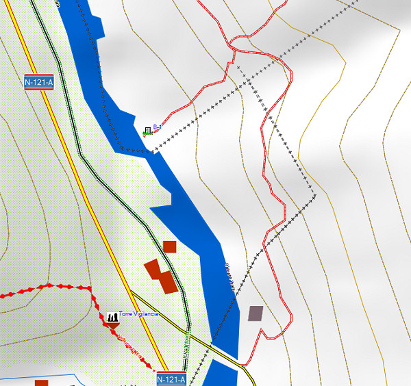
And what does this map offer? Well, every bordermarker is indicated (pillar or cross) but most of all we see many, many trails which we don’t see on the official IGN-maps. You can distinguish between official waymarked trails (and see their names) and other trails. It’s a treasury! An example: the access-routes to bm001:
A shortcut between bm271 and 272: confirmed!

The evidence presented in the previous post has been confirmed by Charles Darrieu. He and his wife Josette tried in 2008 the first part of the shortcut, starting from Col d’Anaye. They didn’t have enough time to climb to the ridge but they found a cairn-waymarked trail uphill.
Moreover: Charles showed how on the Topopirineos-map (see next post) this trail is indicated. And moreover: on Google Earth we can even spot the beginning of it on Col d’Anaye.

I made a kml-file of this connection: esfr-bm271bis-272-connection-on-topopirineos.kml

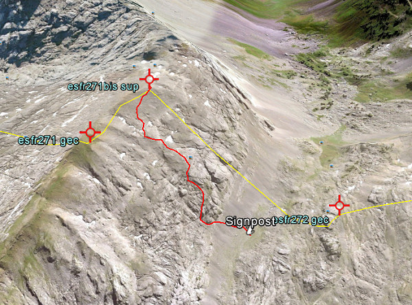
Let’s show some pictures: first an overview of the connection on Google Earth.

And now a view towards Col d’Anaye , approximately on 3/4 of the route from uphill to the Col.

And this picture shows the very beginning, when started from Col d’Anaye. If fact it’s very simple: from the current wooden signpost at Col d’Anaye, climb straight N and soon you will pick up the trail (hito = cairn).


A shorter route between bm271 and 272?

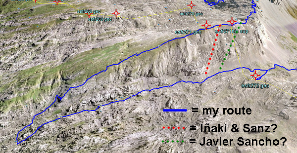
On 20120829 I had to make a large detour to get from bm271 to 272. A shorter descent seemed impossible because of the steepness of the rock-hillside underneath bm271. But I was surprised to read that Iñaki Vigor and Carlos Sanz (see literature) did use a more direct (cairns-waymarked) trail. They also thought it was far too steep. But they found at the saddle between the two hilltops (between bm271 and the former bm271bis) a cairns-trail which took  them without much problems to down below.
Also Javier et María-Jesús Sancho-Esnaola (see this previous post) took a short-cut but their starting point was the saddle east of bm297bis. They talk about following a cairns-trail, descending to the right down a gully (including some rock-scrambling), the route not always being obvious.

In both cases, they must have descended SW. Straight S is – according to the elevation lines – really too steep. Let’s draw it on this Google Earth-capture:

Conclusion: I have to return and check.

Another magazine: les feuilles du Pin à Crochets

This French magazine on the Pyrenees – with a literary style & design – published in 2006 an edition on the border aspects of the Pyrenees. Charles Darrieu told me about it and helped me to receive it. Bibliographic data:
Les feuilles du Pin à Crochets numéro 7 – Pyrenées frontières
Pau : Éditions du pin à crochets, 2006. – ISBN 2-911715-32-2 (website: http://www.editionspinacrochets.com)

It contains 7 articles on a variety of Pyrenean border issues and is illustrated by lots of b&w pictures, including old pictures of borderpasses.

One of the articles has a link with a previous post on this blog. It’s about a ‘disputed’ triangular area between the summit of le Grand Batchimale (or Pic Schrader) and the borderpass with the original bm330. That borderpass was originally named Port de Clarabide but nowadays is shown on the maps as Port d’Agues-Tortes. The current Port de Clarabide is a few kilometers to the east.
The article shows lot of map-samples from over the years and also on older maps we see usually the name Port d’Agues-Tortes or similar. Only a few give it the name ‘Port de Clarabide’.

En busca de los hitos fronterizos

Which means: “in search of the bordermarkers”. I just received this book, mentioned in the previous post. I already learned that the Darrieu-couple are friends of Javier and María-Jesús Sancho-Esnaola. They assembled 6 volumes of information and pictures on the esfr-bordermarkers. That makes one jealous!

This ‘book’ is In fact a special edition of the Spanish magazine Pirineos.
Bibliographic data:
Pirineos Especial 9 – En busco de los hitos fronterizos : rutas por la Muga / Javier Sancho
El mundo de Pirineos. – junio 2010. – 147 p. / ISBN 978-84-8216-450-2

Javier Sancho describes 21 circular routes to bordermarkes – all along the esfr-border -with routes starting both in France and Spain. The maps could have been more elaborate but the photo’s are superb! I put the magazine on my reading list for Christmas to explore the details.


Spanish couple did all the bordermarkers

An unexpected google-find: a Spanish couple who has searched and photographed every bordermarker on the esfr-border. See this this newspaper-article. It reminds me of course of that other – French – couple: Charles et Josette Darrieu who did the same.
Javier Sancho and his wife even published a book on their project, for sale on a lot of on-line bookshops. I immediately ordered it.


New update of www.grpdesbf.nl

It took a lot of work but now it’s ready: see for the update-details and direct links: this webpage

They comprise:
– my trips undertaken in august/september 2012
– one highlight: discovering the exact location of the buried bm196 and trying to excavate it
– another highlight: visiting the recently re-installed bm087
– third highlight: exploring a route from bm271 to 272
– Miguel supplied pictures of the original bm481fr and 482fr
– and an amazing discovery by Jean-Paul Laborie of the original bm330 on the original Port de Clarabide!
– and another discovery: there is a bm310bis bordercross, not yet documented by anyone
– I started a news-blog and set up an email-group