I have already posted a few articles on the new borderline between France and Andorra near the border town of Pas de la Casa. Reason of all this seems a practical one: the since long desire of Pas de la Casa to gain more control over their water resources. Pas de la Casa depends heavily on the upper Ariège-stream and owning the half of the lake of Estany de les Abelletes would guarantee their access to it.
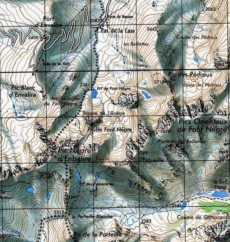
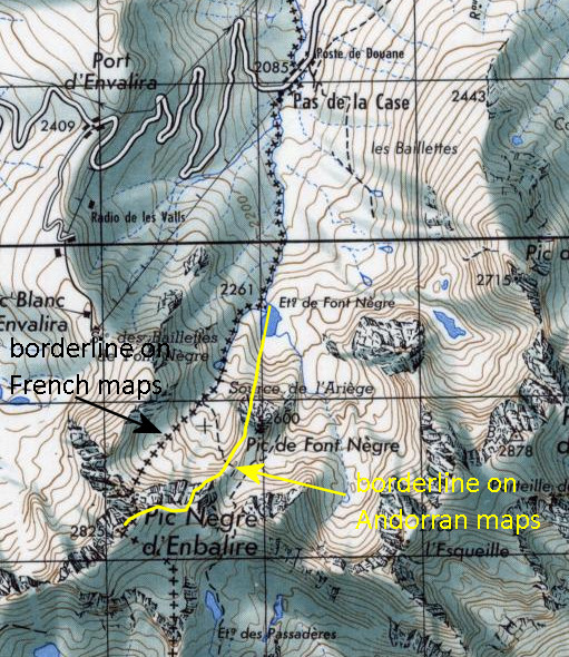
There has never been an official delimitation of the ADFR-border until 2016 following a digitalization of the borderline. For most of the ADFR-border, there were no disputes: the borderline follows the watershed of a high mountain ridge. However: near Pas de la Casa there was a problem. This article explains that the Andorran maps showed the borderline through the middle of the lake of Estany de les Abelletes (splitting it in half between Andorra and France) while the French maps ceded the lake entirely to France including the half of the upper slope towards Pic Nègre d’Enbalire. Let’s show that on an older French IGN-map:
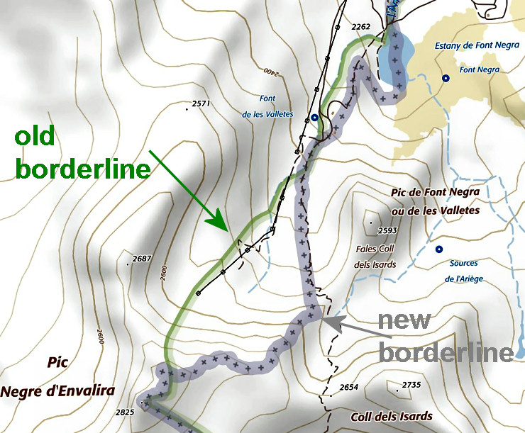
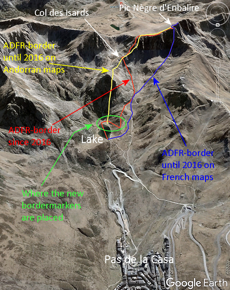
 The negotiations resulted in a new borderline between Col de Isards and the northern point of the lake which has been materialized in recent months by six bordermarkers: three markers and three crosses. Three questions remain to be answered: where are these new markers and crosses placed, how do they look and what is the logic of the new borderline. Let’s try to answer them. But first another map showing the old and new borderlines and the location of the new bordermarkers.
Locations of the new bordermarkers
I was happy to receive a list with coordinates of the new bordermarkers from Sara Pijuan, head of the Andorra Cartography Department. This is the list:
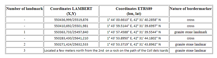
The description of landmark 3 proved to be wrong: it is located 125m south of landmark 2
It took some effort to convert them to wgs84-coordinates and on august 25th during our visit I checked the readings myself (download them as a gpx or kml). They are concentrated around the lake of Estany de les Abelletes. I am looking forward to visit them in two weeks on 25 August. Let’s show their locations in detail on a map with the new borderline. I attributed my own numbers to the six markers to keep all six of them in a numerical order.
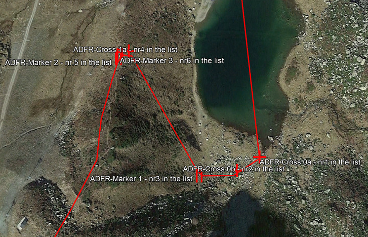
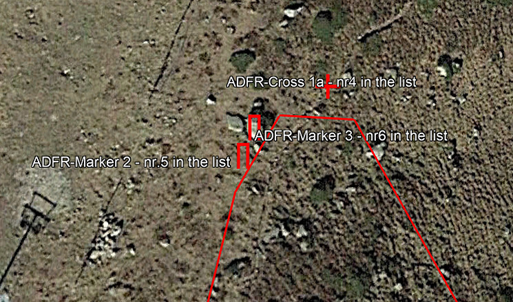
Question 1: why are they only placed in the lower part of this new borderline? I think I know why: see the last paragraph. Another question: he alternation of markers and crosses seems arbitrary, why not six stone markers? But the best judgment of that aspect will be in the terrain itself. Let’s show more in detail the cluster of cross 1a and markers 2 & 3:
The location of marker 3 proved to be wrong in the list, it is in fact 125m to the south of marker2
Why are stone marker 2 and 3 placed so close to another? And in the sequence of the borderline, they should have been exchanged from a numerical point of view: first 2 and then 3. But perhaps it’s an error in the list of Sara. Update: it was indeed an error, in fact marker 3 is located 125m to the south of marker 2.
How do they look?
We have several news-articles (this one, this one and this one) to get information and see pictures. And don’t forget the tweets of the Àrea de Cartografia-institute of Andorra. But I rely on the pictures of the proud stonecutter Damien Breseghello of www.pierrescreations.fr who produced the stone markers and engraved the crosses in the field. He shows them on his Facebook-page.
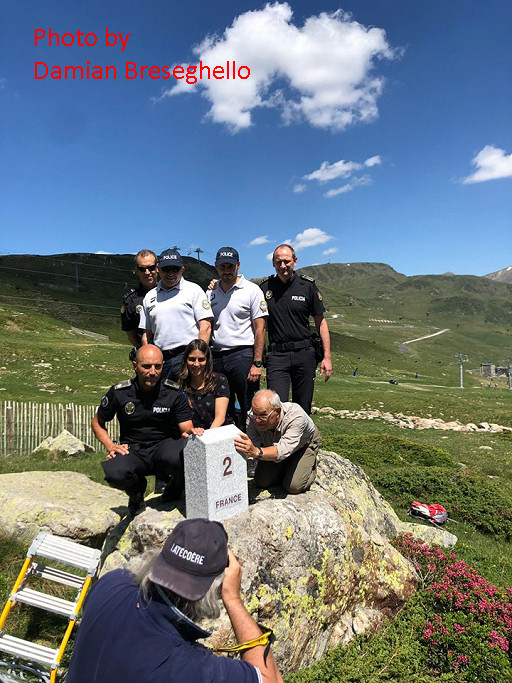
We spot Jean-Paul Laborie (to the right, on his knees), the ‘délégué permanent de la Commission Mixte d’Abornement’. And I think that the lady in this masculine company must be Sara Pijuan.
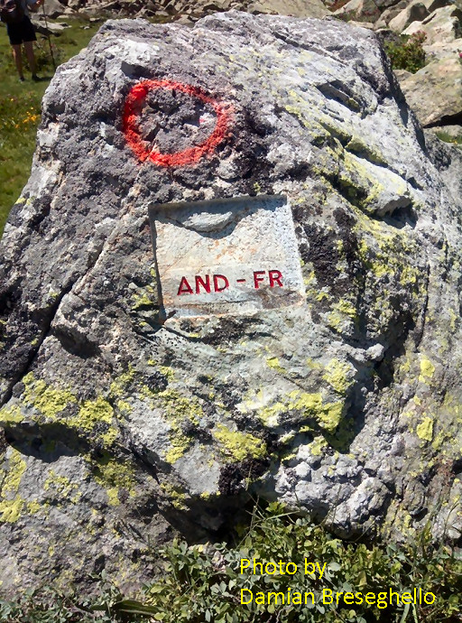
The ‘crosses’ are engraved like plaques, no real crosses engraved or numbers attributed.
About the course of the new borderline
Apparently, there have been negotiations for years to resolve this problem which only could end in France giving up half of the lake. Let’s have a new look on the map with the three borderlines and look for the logic of the new borderline.
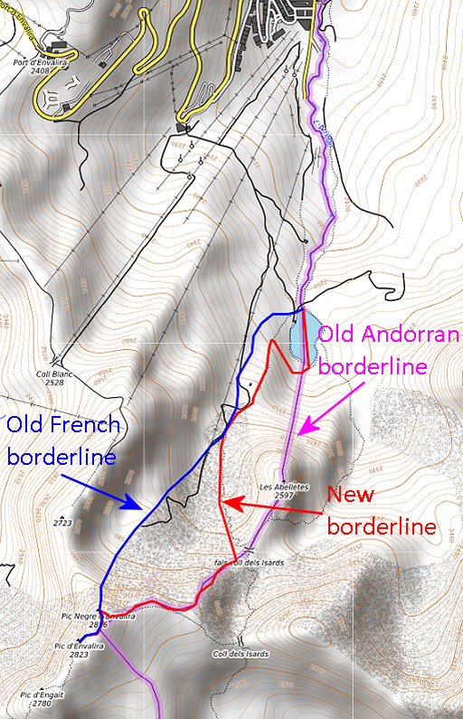
The answer is simple when we study the map: one has tried to attain an equal exchange of terrain. And that makes sense since there is no treaty from the past to rely on, there has never been one. In another bilateral agreement (France-Spain, near Bagnères-the-Luchon), the existing treaty has been violated by an easy solution by cutting up the disputed terrain in half. But that’s another story.
Thus: from the Col des Isards the borderline follows roughly the trail downhill. Close to the lake, it leaves the trail to bend sharply to curve to the south bank of the lake. The trail is very distinct and probably they found it as such a sufficient demarcation. And they decided to restrict the new markers to the last part when the borderline leaves the trail.